


By Henry Brannan
[email protected]
Editor’s note:
This article is the first part of an ongoing series on the history of Indigenous nations in the Grinnell area.
Though frequently associated with Thanksgiving, a U.S. holiday notorious for its whitewashed depictions of history, November is also National American Indian Heritage Month.
In an effort to address locally some of these national conversations about the events and realities which the U.S. is founded upon, this article will briefly outline some of the precolonial history of this area.
In the coming weeks, this series will address how the nations who live or have lived here since time immemorial were dispossessed before looking to the nations today and their present relationships with the College.
LAND AND OWNERSHIP

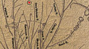
Native-Land.ca’s map of indigenous land in Iowa. (Lance M. Foster (Ioway), vice chair of the Iowa Tribe of Kansas and Nebraska, notes it should only be used as a starting point, as nations were not static.)
In learning what nations are or were here, for many, a helpful starting point is native-land.ca, a tool that allows users to see what nations’ land they are on.
However, Lance M. Foster (Ioway), vice chairman of the Iowa Tribe of Kansas and Nebraska, explains that the “… map is very loose and not super accurate,” but that it is “a starting place for people to understand who was in their neighborhood.”
Foster also points out that each nation, tribe or band had core territories, shared territories and territories that were their neighbors, comparing the core territories to one’s house, shared territories to streets or sidewalks and neighbor’s territories to your neighbor’s house that can go into “… only if you knock on the door and they invite you in.”
Foster also noted that these boundaries were not set in stone, but instead dynamic and that “is the difficulty in assigning” land to particular nations definitively.
Similarly, the property-based conception of ownership that the U.S. is founded on is a newer colonial creation. When Sac and Fox of the Mississippi in Iowa Historical Preservation Director Jonathan L Buffalo (Meskwaki) talks about his nation’s lands, he says “Our land,” before pausing and clarifying, “not meaning in the ownership way, but our land that we live on. When we say our land, we’re not saying it in a legalistic way, but in a cultural way. That we live on this land, in this bioregion, we live in it, and we’re supposed to take care of it.”
THE BEGINNING?
Today, with the Bering Land Bridge Theory losing traction and research placing people in North America increasingly further back in history, popular consensus about people’s origins on the continent is becoming more unstable. A number of different theories fill the void, including many from indigenous nations’ own histories.
THE IOWAY

In Iowa Public Television’s “The First Farmers”, it is noted that the earliest people archaeologists have found evidence of in this region are the Paleo-Indians who roamed around the region while hunting around 12,000 years ago.
8,200 years later, the transition into lifestyles built around agriculture and seasonal travel for hunting would be underway, as William E. Whittiker notes about the Edgewater Park site in what is now Coralville, IA in chapter 39 of his book “The Archaeological Guide to Iowa.” In Foster’s book “The Indians of Iowa,” he explains that archaeologists have found that in the Woodland Period there were a number of native groups there, including the Oneota, who the Ioway, along with the Otoe, Missouria and Ho-Chunk are descended from.
Foster said that these Woodland cultures, located between the Ohio River on the east side, all through what is now Iowa on the west, north to the southern part of what is now Minnesota and as far south as what is now Kansas, were supported by a diverse and thriving ecosystem in the region. However, as population density grew and groups diverged, the Ioway, drawn by new trade opportunities and buffalo “committed to the plains” of this area around 1500 CE, though Foster noted that they had “begun drifting around the year 1200 or so.”
Related groups, like the Mississippians, lived south of the area along the Mississippi River in larger, multi-ethnic metropolises, most notably Cahokia, which the Cahokia Mounds Museum Society describes as the “ … most sophisticated prehistoric native civilization north of Mexico … ” and was home to tens of thousands of people at its peak around 1300 CE.
As evidenced by Chief No Heart of Fear’s 1837 map of Ioway ancestral villages, between the 1300s and 1600s, the Ioway were flourishing. However, Foster notes, this ended as the area was destabilized by a domino effect from conflicts like the The Beaver Wars (1629-1700) between the French-aligned northern Algonquian group of nations and the Dutch- and English-backed Iroquois nations, and then later, the Fox Wars (1712-1735) between the Meskwaki and the French.
These wars, in the St. Lawrence River Valley area of what is now eastern Canada and the Great Lakes region, respectively, created “a great immigration of Algonquian refugees coming from the east into the midwest” who then “overtook a lot of Siouian groups” said Foster.
Some of the last villages departed what is now Iowa in search of peace in the late 1700s and early 1800s. By the time European settlers arrived, the area was mostly inhabited by the Sauk and Meskwaki as well as Sioux groups in the north and west.
THE SAUK AND MESKWAKI

While the Sauk and Meskwaki were newer to what would later become Iowa, they are “ancient on this continent,” said Buffalo. Buffalo notes that the nations, historically from the St. Lawrence River Valley area, slowly moved south and west, “[a]s you go east, we get older.
In Wisconsin, we’re a little bit older, in Michigan we get older. And in Ohio, we’re older. And then, as you go east, we lose our separate identity and we get lost in archaeological terms … but we’re there somewhere.”
This borderline of the nations’ modern and premodern history is Michigan, which Buffalo describes as the land they lived on during parts of both periods. But he also said that their knowledge of their history, as well as the land’s, goes beyond the colonial period.
He said, “[W]e’ve been on this continent for a long time … we’ve seen the world change. I mean weather, you could call it climate change. And we saw the climate destroy the megafauna. Each time a change came, a new life came.”
Despite this immense span of history and the hundreds of miles between their homes throughout it, Buffalo explains that the nations are still within their home, just at the western edge. h
He said, “between Iowa, the Great Lakes, maybe the Kentucky border, onto the east coast, all of that area is what is called a bioregion. We have lived in that region for thousands of years, and we know how to live in this environment … it doesn’t matter if we were in the Saint Lawrence River Valley or Connecticut, Ohio, Michigan, you know. We’re still within our home, our bio-home.
“We’re at the western end of our bioregion, but we’re still within our region. When we look outside our window, we see our gods, we see our world. You know, it’s not alien.”
COLONIAL EXPANSION
While European traders (soon to be colonizers) and the inter-nation conflicts they caused might have forced the Sauk and Meskwaki’s departure from the nations’ pre-modern lands, settlers coming to what would later become Iowa and working together with private enterprises and the U.S. government and military to take land by any means necessary marked another series of changes for the nations spurred by the genocidal project of European westward expansion.
In the next installment of this series, we will look to the specifics of how this land was taken from the nations, how the College came to be and some of the College’s founders’ attitudes and actions towards the nations and towards the U.S. settler colonial project.
FURTHER READING
The following is a list of resources that may be helpful in further building your understanding of this history and its present realities.
Nations’ websites:
The Sac and Fox Tribe of the Mississippi in Iowa (located in Tama, IA)
The Sac and Fox Nation (located in Stroud, OK)
Sac and Fox Nation of Missouri in Kansas and Nebraska (located in Reserve, KS)
Iowa Tribe of Kansas and Nebraska (located in White Cloud, KS)
Iowa Tribe of Oklahoma (located in Perkins, OK).
Other resources
“The Indians of Iowa” – Lance M. Foster
“‘We Dance in Opposite Directions’: Mesquakie (Fox) Separatism from the Sac and Fox Tribe” – Michael D. Green